Posted on Leave a comment

The Megalithic Fortress of Arwad – Syria

The Megalithic Fortress of Arwad - Syria

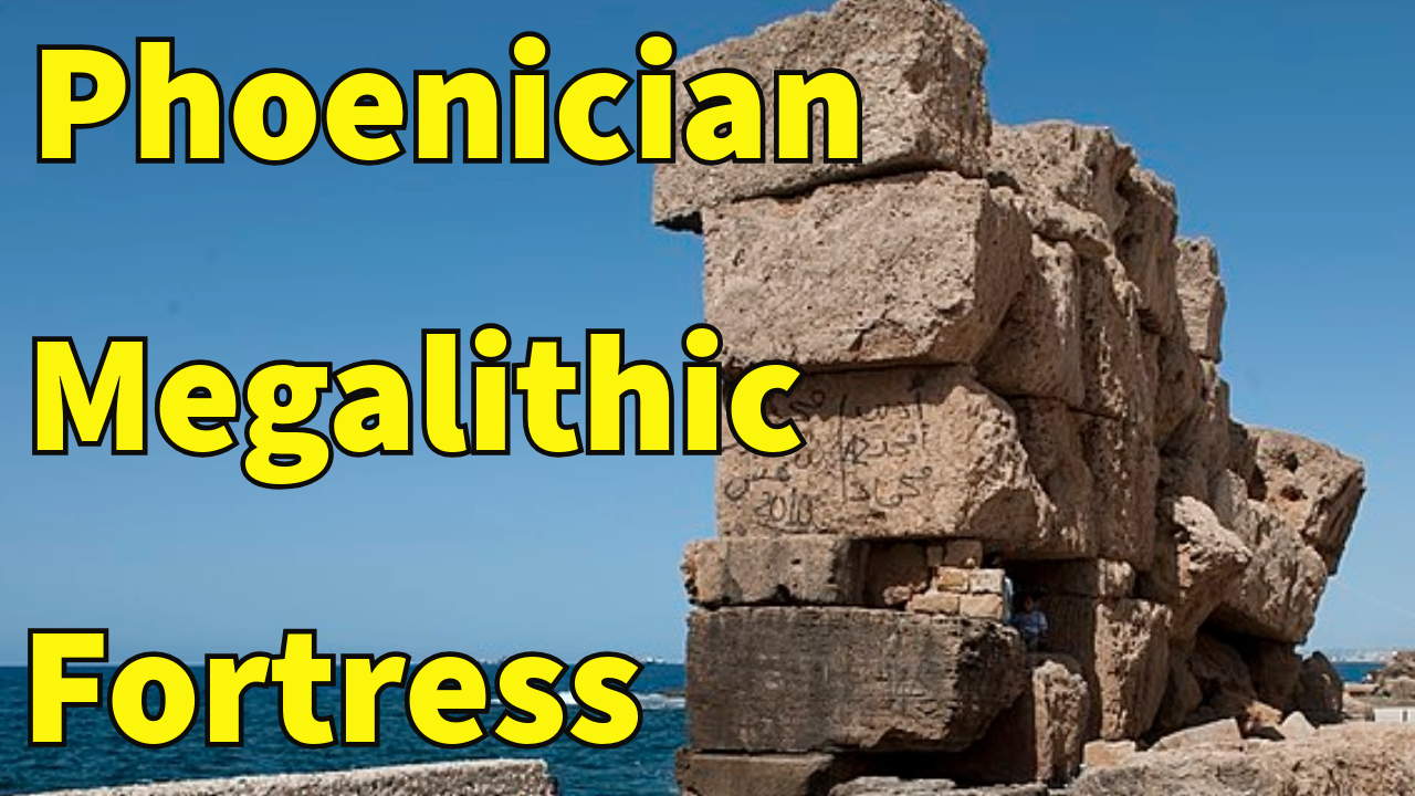
Arwad, an island city situated off the coast of Syria in the Mediterranean Sea, is renowned for its ancient megalithic fortress. A strategic stronghold which has withstood the ravages of time, it offers a fascinating glimpse into the architecture, cultural practices, and historical significance of ancient civilizations in the region.

Historical Background

Also known as Arvad in ancient texts, it was then named Árados in Greek, which was Latinized as Aradus. In Arabic, it became Arwad . It’s also known as Ruad Island.

It is one of the most significant archaeological sites in Syria and its origins date back to the Bronze Age, with the island being continuously inhabited since at least the 3rd millennium BCE. The fortress itself was constructed during the height of Arwad’s prominence, around the 1st millennium BCE, reflecting its strategic importance in ancient maritime trade and defense.

The island was settled in the 2nd millennium BC by the Phoenicians. Under their control, it became an independent kingdom probably called Jazirat (meaning “island”) or Aynook. The city has been cited as one of the first known examples of a republic in the world, in which the people, rather than a monarch, are described as sovereign.

It was a major city-state, and the Phoenicians, known for their seafaring prowess and commercial enterprises, established Arwad as a crucial port city. The island’s location, just off the Syrian coast, allowed it to control important maritime routes and engage in trade with various Mediterranean civilizations, including Egypt, Greece, and Rome.

The fortress was built during a period of heightened geopolitical tensions and conflicts. The city-state faced threats from neighboring powers, including the Assyrians, Babylonians, and later the Macedonians and Romans. The fortress’s construction was thus a response to these external pressures and a testament to Arwad’s strategic military planning.

“The King of Arwad dwelt in the wide sea and fixed his dwelling like a fish in immeasurable waters.” –Ashurbanipal, King of Assyria-

Arwad apparently received the favor of the Seleucid Kings of Syria, and enjoyed the right of asylum for political refugees. Also, in some documents in connection with other cities and rulers of the near East, it is mentioned to show favor to the Jews.

This was after Rome had begun to interfere in the affairs of Judea and Syria, and indicates that Arwad was still of considerable importance at the time.

It formed an excellent base for the Phoenician commercial operations, into both the hinterland as far as the Euphrates, and also to Egypt. It was not until Roman times that the island declined, losing its commercial power to Antaradus (Ṭarṭus).

Tartus or Tartous with over 160,000 inhabitants is today the second most important town on the Syrian coast after Latakia. It is situated on the Mediterranean Sea, opposite Arwad Island.

Tartus was founded in antiquity as Antaradus (Anti-Aradus or the town facing Aradus), as a Phoenician colony of Arwad/Aradus. It was rebuilt in 346 AD by Emperor Constantine the I and flourished during Roman and Byzantine times. It became a major Christian stronghold and it is claimed to have the first chapel dedicated to the Virgin Mary.

In the 12th and 13th century AD, Crusaders occupied Tartus, then known as Tortosa, converting it into a fortress-town, and successfully defending it against attacks. It finally fell to the Arabs, who razed the walls, in 1302.

In November 1300, Jacques de Molay, last Grand Master of the Knights Templar, and Amaury de Lusignan, Lord of Tyre, attempted to occupy the former Templar stronghold of Tortosa.

A force of 600 men, of which the Templars supplied about 150, failed to establish itself in the town, although they were able to leave a garrison of 120 men on the Island of Ruad (Arwad), just off the coast.

Nearly forty of these men were still in prison in Cairo, Egypt, years later, where according to a former Genoese fellow prisoner, they died of starvation, having refused an offer of many riches and goods in return for apostatizing.

Tortosa was the last stand the Templars had on the mainland of Syria towards Arwad, which they kept for another decade.

From the beginning of the Ottoman conquest, the town declined in importance until its port was rejuvenated in the 20th century.

Today, there is a Templar castle and an Arab castle, both dating from the 13th century, still to be seen on Arwad, which is now an entirely Arab island dependent for its livelihood on the fishing industry. Arwad can be reached by boat from Tartus.

Architectural Features

The megalithic fortress stands out due to its impressive and sophisticated architectural features. The term “megalithic” refers to the use of large stone blocks in construction, which is evident in its massive walls and defensive structures.

These walls, which are up to 12 meters (40 feet) high and 5 meters (16 feet) wide, were designed to withstand both sieges and assaults. They provided strength, but also durability, allowing the fortress to endure over millennia.

The walls were built using large, finely cut stone blocks, many of which are polygonal in shape. This construction method was highly advanced for its time and reflects the skill and sophistication of the builders. They were equipped with towers and bastions at strategic points. These towers provided elevated vantage points for defenders and allowed for effective surveillance and defense of the fortress.

The bastions were designed to enfilade enemy troops, creating a crossfire that was highly effective in repelling attacks.

The fortress had multiple gates, each fortified and protected by complex gatehouses. The main gate was particularly elaborate, featuring a series of defensive barriers and traps designed to slow down and confuse attackers. This gate was flanked by two massive towers, each with arrow slits and defensive platforms.

    Within the walls, the internal layout was organized for both residential and military purposes. The fortress contained living quarters for the garrison, administrative buildings, and storage facilities.

    The design of the internal spaces reflected a high degree of organization and functionality, ensuring that the fortress could support a prolonged siege, if necessary.

    Strategic Importance

    The strategic location of Arwad’s fortress was central to its historical significance. The island’s position in the Mediterranean Sea provided it with several key advantages.

    Phoenician Influence

    The island was a center of Phoenician culture, known for its shipbuilding and trade networks. Some of the inscriptions and artifacts found on the island provide insight into the Phoenician language and religious practices.

    Maritime Control

    Arwad’s location allowed it to control important maritime routes. The fortress overlooked the sea lanes used by merchant ships traveling between the eastern coasts and the wider Mediterranean region. By controlling these routes, Arwad could exert influence over trade and commerce, and secure its position as a major port city.

    Defense Against Invasion

    The fortress was strategically designed to defend against maritime and land-based invasions. Its elevated position on the island made it difficult for invaders to approach and launch a successful attack. The combination of thick walls, defensive towers, and the surrounding sea, created a formidable barrier that protected the city from numerous sieges and assaults.

    Economic and Political Power

    Arwad’s control over maritime trade routes contributed to its economic prosperity. The fortress not only defended the city but also symbolized its political and economic power. The presence of such a strong defensive structure indicated the city’s wealth and its ability to project power regionally and beyond.

    Ancient Harbor

    Arwad’s strategic position made it an important maritime hub in antiquity. The island has remnants of an ancient harbor system, which underscores its significance as a port city and its role in trade and military operations across the Mediterranean.

    Historical Significance

    Arwad played a significant role during various historical periods, including the Persian and Roman eras. It was often a point of contention and a strategic asset due to its location and fortifications.

    Cultural Continuity

    The island has been continuously inhabited for thousands of years, and it has retained much of its ancient character. Even in modern times, the local population still engages in traditional practices that reflect the island’s long history.

    Maritime Heritage

    Arwad has a rich maritime history, with evidence of ancient shipbuilding techniques and naval activities. The presence of ancient shipyards and related infrastructure highlights its role in maritime trade and warfare.

    These aspects of Arwad add depth to our understanding of its historical and cultural significance, making it a truly remarkable site with a rich heritage that extends beyond the well-known aspects of its megalithic fortifications.

    The fortress holds significant historical value. It is a testament to the advanced engineering and architectural skills of ancient civilizations and reflects the broader cultural and political context of the time. Its design influenced subsequent fortifications in the region and contributed to the development of military architecture in the ancient Mediterranean world.

    Excavations and studies of the fortress have provided important information about ancient construction techniques, defensive strategies, and the daily life of the inhabitants.

    The insights gained from studying Arwad’s fortress contribute to our understanding of ancient civilizations, their military strategies, and their cultural practices.

    As research and excavation continue, the fortress of Arwad will undoubtedly yield further revelations about its past and its impact on the ancient Mediterranean world.

    What do you think about The Megalithic Fortress of Arwad and other Megalithic structures in the world? Let us know in the comment section below and share the post!!!


    Video version here:

    The Megalithic Fortress of Arwad – Syria


    Interesting sources, additional info, images, credits, attributions and other points of views here:

    https://en.wikipedia.org/wiki/Arwad

    https://www.aramcoworld.com/Articles/January-2016/Arwad-Fortress-at-Sea

    https://homsonline.com/EN/Citeis/Tartus.htm

    https://en.wikipedia.org/wiki/Fall_of_Ruad

    https://www.megalithicbuilders.com/asia/syria/arwad-arwad-wall

    SOURCES:

    • Malcolm Barber, Trial of the Templars
    • Martin Bernal, Black Athena Writes Back (Durham: Duke University Press, 2001), 359.
    • Lawrence I Conrad, ‘The Conquest of Arwād: A Source-critical study in the historiography of the early medieval Near East’, in The Byzantine and early Islamic Near East: Papers of the First Workshop on Late Antiquity and Early Islam, edited by Averil Cameron and Lawrence I Conrad, Studies in late antiquity and early Islam, 1, vol. 1, Problems in the literary source material (Princeton: Darwin Press, 1992), 317–401.
    • Alain Demurger, The Last Templar
    • Hazlitt, The Classical Gazetteer, p.53.
    • Lebling, Robert W. 2016. “Arwad, Fortress at Sea”. Aramco World. January February 2016. Volume 67, no. 1. Pages 34–41.
    • Newman, Sharan (2006). Real History Behind the Templars. Berkley Publishing Group. ISBN 978-0-425-21533-3.
    • Jean Richard, Les Croisades
    • Sylvia Schein, “Gesta Dei per Mongolos”
    • Dave Eggers, Zeitoun
    • Krahmalkov, Charles R (2000). Phoenician-Punic dictionary. Peeters Publishers.

    PICS:

    https://commons.wikimedia.org/wiki/File:Ruad_large.jpg

    https://commons.wikimedia.org/wiki/File:Ruad_small.jpg

    https://commons.wikimedia.org/wiki/File:Cours_de_la_forteresse_d%27Arouad.jpg

    https://commons.wikimedia.org/wiki/File:St%C3%A8le_alb%C3%A2tre_syrie_Aruad_Arados_Louvre_AO4815.jpg

    https://commons.wikimedia.org/wiki/File:Seal_of_Pantherios,_Bishop_of_Aradus_(Schlumberger,_1900).png

    https://commons.wikimedia.org/wiki/File:Views_of_Sepulchral_Monuments_near_Aradus_A_Plan_of_an_Open_Temple_X_A_View_of_a_Throne_in_T_The_Island_Aradus_C_-_Pococke_Richard_-_1745.jpg

    https://commons.wikimedia.org/wiki/File:The_island_of_Tortosa_-_Mayer_Luigi_-_1810.jpg

    https://commons.wikimedia.org/wiki/File:Arwad_general_view_0732.jpg

    https://commons.wikimedia.org/wiki/File:Arwad_ancient_harbour_area_3536_merge.jpg

    https://commons.wikimedia.org/wiki/File:Arwad_general_view_0991.jpg

    https://commons.wikimedia.org/wiki/File:Arwad_general_view_3578.jpg

    https://commons.wikimedia.org/wiki/File:Arwad_old_harbour_area_3565.jpg

    https://commons.wikimedia.org/wiki/File:Arwad_Ottoman_era_lighthouse.jpg

    https://commons.wikimedia.org/wiki/File:Ifpo_23352_Syrie,_gouvernorat_de_Tartous,_District_de_Tartous,_%C3%AEle_de_Raouad,_vue_a%C3%A9rienne_oblique.jpg

    https://commons.wikimedia.org/wiki/File:Le_Tour_du_monde-07-p044-crop.jpg

    https://commons.wikimedia.org/wiki/File:PAB_Ile_de_Rouad_Aradus.jpg

    https://commons.wikimedia.org/wiki/File:Arwad_al-Burj_Ayyubid_fortress_3520.jpg

    https://commons.wikimedia.org/wiki/File:Arwad_al-Burj_Ayyubid_fortress1206.jpg

    https://commons.wikimedia.org/wiki/File:Castle_in_the_island_of_Tortosa_-_Mayer_Luigi_-_1810.jpg

    https://commons.wikimedia.org/wiki/File:Arwad_Castle_%E9%98%BF%E7%93%A6%E5%BE%B7%E5%8F%A4%E5%A0%A1_-_panoramio.jpg

    https://commons.wikimedia.org/wiki/File:Arwad_citadel_0712.jpg

    https://commons.wikimedia.org/wiki/File:Arwad_citadel_3598.jpg

    https://commons.wikimedia.org/wiki/File:Syria_Ethno-religious_composition..jpg

    https://commons.wikimedia.org/wiki/File:JacquesdeMolay.jpg

    https://commons.wikimedia.org/wiki/File:Phoenicia_map-en.svg

    https://en.wikipedia.org/wiki/Phoenicia#/media/File:Construction_of_Xerxes_Bridge_of_boats_by_Phoenician_sailors.jpg

    https://commons.wikimedia.org/wiki/File:Coin_of_Abdashtart_I,_Achaemenid_Phoenicia_(2).jpg

    https://pixabay.com/illustrations/templar-knight-sword-medieval-8885310

    https://pixabay.com/illustrations/knight-templar-knight-templar-8450835

    https://en.wikipedia.org/wiki/Phoenicia#/media/File:Phoenician_trade_routes_(eng).svg

    https://en.wikipedia.org/wiki/Seleucid_Empire#/media/File:Seleucid_Empire_alternative_map.jpg

    https://en.wikipedia.org/wiki/Seleucid_Empire#/media/File:Seleucid-Empire_200bc.jpg
    Posted on Leave a comment

    Lost Lands and Phantom Islands: Exploring the Mysteries of Earth’s Vanishing Geographies

    Lost Lands and Phantom Islands - Earth's Vanishing Geographies

    The appeal of lost lands and phantom islands has captivated human imagination for centuries. These geographical enigmas, often mentioned in myths, legends, and early navigational charts, evoke a sense of mystery and adventure. They represent places that once appeared on maps or in tales, but have since eluded discovery or been debunked as fictional. This research delves into the fascinating realms of lost lands and phantom islands, exploring their origins, cultural significance, and the explanations behind their existence.

    Origins and Historical Accounts

    Lost lands and phantom islands have their origins in ancient cartography and folklore, where accounts of distant and mysterious lands fueled the imaginations of explorers and scholars alike. One of the most famous examples is Atlantis, the mythical island first mentioned by Plato in his dialogues. Plato described Atlantis as an advanced civilization that sank into the sea in a single day and night, sparking countless theories and expeditions in search of its remains.

    In medieval times, maps depicted fantastical islands like Thule, believed to be the northernmost land reachable by ancient voyagers. Thule and similar islands represented the edge of the known world, beyond which mystery and the great unknown where located. These tales often intertwined with religious beliefs and cosmological ideas, shaping the worldview of societies.

    Exploration and Encounters

    During the Age of Exploration, European sailors encountered numerous phantom islands that appeared on maps but vanished upon closer inspection. These islands were sometimes the result of navigational errors, optical illusions caused by atmospheric conditions, or the misinterpretation of natural features such as icebergs or volcanic eruptions.

    For instance, Buss Island, reported by several explorers in the Arctic, turned out to be a mirage caused by unusual atmospheric refraction.

    Explorers like Cristoforo Colombo famously searched for mythical islands such as Antillia, believed to lie west of Portugal and Spain. The quest for these elusive lands drove exploration and pushed the boundaries of geographical knowledge, contributing to both scientific discovery and cultural exchange.

    Cultural Significance and Mythology

    Beyond their geographical implications, lost lands and phantom islands hold profound cultural significance. They often feature in myths and legends as paradises, utopias, or realms inhabited by supernatural beings. The tale of Avalon, the legendary island associated with King Arthur and the Lady of the Lake, embodies themes of immortality and otherworldly beauty. These narratives resonate across cultures, reflecting human desires for discovery, escape, and transcendence.

    In folklore, phantom islands sometimes serve as cautionary tales, warning sailors of treacherous waters or marking the boundaries between the known and the unknown. They blur the lines between reality and fantasy, offering glimpses into the collective psyche of civilizations throughout history.

    Scientific Explanations and Modern Understanding

    Modern science claims to have unraveled many mysteries surrounding lost lands and phantom islands. Satellite imagery, sonar mapping, and advanced geo-spatial technologies have allowed researchers to confirm the existence or non-existence of these elusive features. For example, the island of Bermeja, once thought to lie off the coast of Mexico, was officially disproven in the 20th century through systematic surveys.

    Moreover, geological processes such as tectonic activity, sea level changes, and erosion, provide some explanations for the disappearance of landmasses over time. Islands may submerge due to volcanic activity, coastal erosion, or shifts in the Earth’s crust, somewhat demystifying once-mythical places and revealing the dynamic nature of our planet’s geography.

    Contemporary Examples and New Discoveries

    Despite scientific advancements, tales of lost lands and phantom islands persist into the contemporary era.

    Furthermore, ongoing exploration of the Arctic and Antarctic regions continues to unveil new geological features and underwater landforms previously unknown to science.

    The following list of 20 lost lands and 20 phantom islands highlights the evolving nature of geographical knowledge and the interconnectedness of cultural narratives with scientific inquiry.

    Lost Lands (Geography and Mythology):

    1. Atlantis: The most famous lost land, described by Plato as a highly advanced civilization that sank into the sea.
    2. Lemuria, also called Mu: A hypothetical lost continent in the Indian Ocean called Kumari Kandam, proposed in the 19th century to explain geological and biological similarities between India and Madagascar. Legendary lost continent, proposed by Augustus Le Plongeon as the homeland of the Maya civilization, now largely considered a pseudoscientific concept.
    3. Hy-Brasil: A phantom island off the coast of Ireland in Celtic mythology, said to appear every seven years and be shrouded in mist. Some researchers consider it to be a vanished land connected to present-day Brasil.
    4. Thule: In ancient Greek and Roman literature, Thule was a distant place located beyond the borders of the known world, often associated with Scandinavia or Iceland.
    5. Avalon: A legendary island in Arthurian legend, associated with King Arthur and said to be the place where the sword Excalibur was forged and where Arthur was taken after his death.
    6. Lyonesse: A mythical land said to have existed off the coast of Cornwall, England, now submerged beneath the sea.
    7. Ys: A legendary city in Breton folklore, said to have been submerged beneath the sea due to the pride and sins of its inhabitants.
    8. Greater Adria: It is named after Adria, a geologic region found in Italy, where evidence of the microcontinental fragment was first observed. Greater Adria’s size can be compared to that of modern day Greenland.The only part remaining relatively intact is a strip running from Turin and Istria to the Heel of Italy, under the Adriatic Sea. Most of the remains are 1,000 kms (620 mi) under Europe, deep in the earth.
    9. Zealandia, also known as Te Riu-a-Māui for the Maori, or Tasmantis, is an almost entirely submerged mass of continental crust in Oceania. Satellite imagery shows it to be almost the size of Australia. A 2021 study suggests Zealandia is over a billion years old, about twice as old as geologists previously thought.
    10. Neolithic Malta:When Malta was still connected by land to Sicily, circa 12,000 years ago, the site of Marsaxlokk towered at least 150 metres above sea-level.
    11. Balkanatolia. It was an island continent or a series of islands, separate from Asia and also from Western Europe. The area now comprises approximately the modern Balkans and Anatolia.
    12. Beringia: Today is defined as the land and maritime area around the Bering Strait. At various times, it formed a land bridge referred to as the Bering land bridge, that was up to 1,000 kms (620 mi) wide at its greatest extent and which covered an area as large as British Columbia and Alberta combined.
    13. Doggerland. It was an area of land in Northern Europe, now submerged beneath the North Sea, that connected Britain to continental Europe. Geological surveys have suggested that it stretched from what is now the east coast of Great Britain to what is now the Netherlands, the western coast of Germany and the Danish peninsula of Jutland.
    14. Dvaraka, an ancient submerged city in modern-era Gujarat, India. Modern Dwarka. It’s known as a Hindu pilgrimage site.
    15. Graham Island/Isola Ferdinandea is a submarine volcano in the Mediterranean Sea near Sicily that has, on more than one occasion, risen above the surface via volcanic action and soon thereafter been washed away. Since 300 BC this cycle of events has occurred four times.
    16. Kerguelen Plateau: One of the largest igneous provinces in the world, it covers an area three times the size of California. It rises 2,000m (6,600 ft) above the surrounding oceanic basins. Most of the plateau is less than 3,000 m (9,800 ft) below sea level. It’s located in the Southern Indian Ocean.
    17. Maui Nui: Located in the US state of Hawaii. Built from seven shield volcanoes. It broke up as rising sea levels flooded the connections between the volcanoes, creating the islands of the modern-era state.
    18. Sundaland is a region of Southeast Asia corresponding to a larger landmass that was exposed millions of years ago during periods when sea levels were lower. It includes Bali, Borneo, Java, Sumatra in Indonesia, and their surrounding small islands, as well as the Malay Peninsula on the Asian mainland.
    19. Viking-Bergen Banks are underwater hills in the North Sea, east of the Shetland Islands and west of Norway. When sea levels were lower during the Last Glacial Period, the hills formed an island that may have been occupied by humans.
    20. Buyan, an island with the ability to appear and disappear in Slavic mythology.

    Phantom Islands:

    1. Sandy Island: A phantom island that appeared on maps in the Coral Sea, supposedly located between New Caledonia and Australia. It was listed as non-existent in 2012.
    2. Frisland: A phantom island shown on maps in the North Atlantic Ocean during the Age of Discovery, now believed to have been a cartographic error.
    3. Buss Island: Reported by several explorers in the Arctic, Buss Island turned out to be a mirage caused by unusual atmospheric refraction.
    4. St. Brendan’s Island: A phantom island in the Atlantic Ocean, appearing on maps from the 15th to 18th centuries, named after the legendary Irish saint.
    5. Antillia: A phantom island west of Portugal and Spain, appearing on maps during the Age of Discovery, possibly originating from tales of Atlantis.
    6. Emerald Island: Reported to lie between Australia and Antarctica and south of Macquarie Island. Said to be a lush, green paradise.
    7. Crocker Land: A phantom island supposedly sighted during an Arctic expedition, later found not to exist. A hoax invented by explorer Robert Peary to gain more financial aid from George Crocker, one of his financial backers.
    8. Aurora Islands: Phantom islands reported in the South Atlantic, believed to be visible only under specific weather conditions.
    9. St. Matthew Island: A phantom island once thought to lie roughly one thousand kilometers northeast of Ascension Island in the Atlantic Ocean. It appeared on navigational charts as late as the twentieth century.
    10. Isle of Demons: A phantom island reported by sailors in the North Atlantic in Canada. It was believed that the island was populated by demons and wild beasts which would torment and attack any ships that passed, or anyone that was foolish enough to wander onto the island.
    11. Island of Mayda: A non-existent island in the North Atlantic that has been shown on several published maps at various points in history. It was most often represented as being crescent-shaped and its position has varied widely over time. Early maps drew the island west of Brittany and southwest of Ireland.
    12. Porcupine Bank: A phantom island reported off the west coast of Ireland, believed to have been a misidentification of a shallow bank.
    13. Anaa-ti. Located in French Polynesia in the Southern Pacific Ocean. Believed to be a mistaken sighting of a nearby island.
    14. Antonio de Ulloa Island.Discovered by the Spanish captain Antonio de Ulloa in the South Pacific Ocean. Noted as doubtful in 1875.
    15. Arthur Island. Phantom Island in the South Pacific Ocean. Noted to be needing confirmation of existence and position in 1851; not seen on modern maps.
    16. Bermeja.Discovered in the early 16th century by Spain, but mysteriously vanished sometime during the 17th century. A phantom island off the coast of the Yucatán Peninsula, Mexico, which appeared on maps until it was disproven in the 20th century. While no dominant theory holds, it is possible that the island submerged due to tectonic movements, nearby Scorpion Reef.
    17. Bonetta Rocks.Location given between Cape Verde and Mauritania. Could not be found in 1838.
    18. Cassiterides. Ancient source of Phoenician tin. Exact location unknown but thought to have possibly referred to now silt-connected islands within the marshes of Briere.
    19. Davis Land. Supposedly sighted by the pirate Edward Davis in the Pacific along the same latitude as the Spanish-controlled gold mines of Copiago. At the time, it was believed that gold could be found elsewhere along the latitude, so several navigators were instructed to search for it. Never found, it was also believed by William Dampier to be the coast of Terra Australis Incognita.
    20. Cloate’s Island. West of Australia. Removed from charts by 1856 or earlier.

    These lost lands, vanished cities and phantom islands have fascinated explorers, historians, and cartographers throughout history, blending myth, folklore, and geographical exploration into a rich tapestry of cultural narratives and mysteries.

    They represent more than mere geographical curiosities—they embody the human spirit of exploration, imagination, and discovery.

    From ancient myths to modern scientific scrutiny, these enigmatic features have shaped historical narratives and cultural identities across civilizations. Their legacy endures in literature, art, and the collective consciousness.

    What do you think about lost lands and phantom islands? Let us know in the comment section below and share the post!!!


    Video version here:

    Lost Lands and Phantom Islands


    Interesting sources, additional info, images, credits, attributions and other points of views here:

    https://en.wikipedia.org/wiki/List_of_lost_lands

    https://en.wikipedia.org/wiki/Greater_Adria

    https://en.wikipedia.org/wiki/Zealandia

    https://en.wikipedia.org/wiki/Balkanatolia

    https://en.wikipedia.org/wiki/Beringia

    https://en.wikipedia.org/wiki/Doggerland

    https://en.wikipedia.org/wiki/Dv%C4%81rak%C4%81 Dwarka

    https://en.wikipedia.org/wiki/Graham_Island_(Mediterranean_Sea)

    https://en.wikipedia.org/wiki/Kerguelen_Plateau

    https://en.wikipedia.org/wiki/Maui_Nui

    https://en.wikipedia.org/wiki/Sundaland

    https://en.wikipedia.org/wiki/Viking-Bergen_Banks

    https://en.wikipedia.org/wiki/Atlantis

    https://en.wikipedia.org/wiki/Avalon

    https://en.wikipedia.org/wiki/Buyan

    https://en.wikipedia.org/wiki/Kumari_Kandam (Lemuria)

    https://en.wikipedia.org/wiki/Lemuria

    https://en.wikipedia.org/wiki/Mu_(mythical_lost_continent)

    https://en.wikipedia.org/wiki/Ys

    https://en.wikipedia.org/wiki/Phantom_island

    Further reading

    Credits/Attributions

    https://commons.wikimedia.org/wiki/File:Kumari_Kandam_map.png

    https://commons.wikimedia.org/wiki/File:Ortelius_1572_Ireland_Map_2.jpg

    https://commons.wikimedia.org/wiki/File:Thule_carta_marina_Olaus_Magnus.jpg

    https://commons.wikimedia.org/wiki/File:StampThule1935Michel3.jpg

    https://commons.wikimedia.org/wiki/File:Burne-Jones_Last_Sleep_of_Arthur_in_Avalon_v2.jpg

    https://commons.wikimedia.org/wiki/File:The_Death_of_King_Arthur.jpg

    https://commons.wikimedia.org/wiki/File:Bronze_Age_Scilly_Coastline_in_3,000_BC.png

    https://commons.wikimedia.org/wiki/File:Evariste-Vital_Luminais_-_Fuite_de_Gradlon.jpg

    https://commons.wikimedia.org/wiki/File:383_Kerlaz.jpg

    https://en.wikipedia.org/wiki/File:Auguste_Fran%C3%A7ois-Marie_Gorguet_-_poster_for_the_premi%C3%A8re_performance_of_%C3%89douard_Lalo%27s_Le_roi_d%27Ys_(1888).jpg

    https://commons.wikimedia.org/wiki/File:Zealandia_topography.jpg

    https://commons.wikimedia.org/wiki/File:Malta_relief_location_map.png

    https://www.cnrs.fr/en/press/balkanatolia-forgotten-continent-sheds-light-evolution-mammals

    https://commons.wikimedia.org/wiki/File:Beringia_land_bridge-noaagov.gif

    https://commons.wikimedia.org/wiki/File:Beringia_-_late_wisconsin_glaciation.png

    https://commons.wikimedia.org/wiki/File:Doggerland.svg

    https://commons.wikimedia.org/wiki/File:Doggerbank.jpg

    https://commons.wikimedia.org/wiki/File:Dwarka1.jpg

    https://commons.wikimedia.org/wiki/File:Dwarkadhish_Temple_20.jpg

    https://commons.wikimedia.org/wiki/File:Map_of_Graham_Island.jpg

    https://commons.wikimedia.org/wiki/File:HMS_Melville_and_Graham_Island.jpg

    https://commons.wikimedia.org/wiki/File:KerguelenPlateau_v1.png

    https://commons.wikimedia.org/wiki/File:Bathymetry_image_of_the_Hawaiian_archipelago.png

    https://commons.wikimedia.org/wiki/File:Map_of_Sunda_and_Sahul.svg

    https://commons.wikimedia.org/wiki/File:North_Sea_map-en.png

    https://commons.wikimedia.org/wiki/File:Ivanbilibin.jpg

    https://commons.wikimedia.org/wiki/File:Sandy_Island_on_1908_chart_-_cropped.jpg

    https://commons.wikimedia.org/wiki/File:Bermeja.jpg

    https://commons.wikimedia.org/wiki/File:Map_by_nicolo_zeno_1558.jpg

    https://commons.wikimedia.org/wiki/File:Buss_Island.jpg

    https://commons.wikimedia.org/wiki/File:St_Brendan%27s_island.jpg

    https://commons.wikimedia.org/wiki/File:Portolan_chart_by_Albino_de_Canepa_1489.jpg

    https://commons.wikimedia.org/wiki/File:Antarctica_1912_edit.jpg

    https://commons.wikimedia.org/wiki/File:Bradley_Land.jpg

    https://commons.wikimedia.org/wiki/File:Lwsam_1808.jpg

    https://commons.wikimedia.org/wiki/File:Theatrum_Orbis_Terrarum_-_Africae_Tabula_Nova.jpg

    https://commons.wikimedia.org/wiki/File:TerreNeuve16e.jpg

    https://commons.wikimedia.org/wiki/File:Mayda_Pizigani.jpg

    https://commons.wikimedia.org/wiki/File:Porcupine_Bank_and_Seabight,_NE_Atlantic.png

    https://commons.wikimedia.org/wiki/File:Polyn%C3%A9sie_fran%C3%A7aise_collectivity_location_map.svg

    https://commons.wikimedia.org/wiki/File:Pacific_Ocean_-_en.png

    https://en.wikipedia.org/wiki/File:South-pacific-map.jpg

    https://commons.wikimedia.org/wiki/File:Cape_Verde_(orthographic_projection).svg

    https://commons.wikimedia.org/wiki/File:Map_of_Europe_according_to_Strabo.jpg

    https://commons.wikimedia.org/wiki/File:AMH-8032-KB_Map_of_the_Pacific_Ocean,_with_Australia_and_the_west_coast_of_South_America.jpg

    https://commons.wikimedia.org/wiki/File:Exmouth_caperange_beach.jpg

    https://pixabay.com/photos/desert-mountains-landscape-orange-4830921

    https://pixabay.com/photos/sea-ocean-expanse-blue-water-1090586

    https://pixabay.com/photos/desert-badlands-panorama-barren-1170055

    https://pixabay.com/illustrations/desert-cave-lonely-alone-planet-7667243

    https://pixabay.com/photos/plank-choice-home-or-lost-home-729441

    https://pixabay.com/photos/lost-found-lost-and-found-searching-1605501

    https://pixabay.com/photos/landscape-mountains-meadow-heaven-3530951

    https://pixabay.com/photos/wheat-grain-field-land-agriculture-3494280

    https://pixabay.com/photos/desert-arid-land-landscape-drought-5507220

    https://pixabay.com/photos/desert-mountains-countryside-74781

    https://pixabay.com/photos/land-scape-big-sky-custer-dakota-3485399

    https://pixabay.com/photos/island-sea-costa-clouds-sunset-7756423

    https://pixabay.com/photos/island-tropical-beach-palm-trees-1285147

    https://pixabay.com/photos/beach-island-landscape-ocean-2179361

    https://pixabay.com/photos/island-sea-ocean-horizon-sunset-1867510

    https://pixabay.com/photos/ocean-mountain-sunset-island-3740996

    https://pixabay.com/photos/ocean-beach-water-sand-nature-4270249

    https://pixabay.com/photos/tropical-island-blue-ocean-beach-5074304

    https://pixabay.com/photos/island-bora-bora-tahiti-7335510

    https://pixabay.com/photos/clouds-fog-mist-island-nature-1850093